
How does GPS Tracking work?
We often get questions about the differences between different satellite networks and how our tracking works. Here we share an overview of how GPS tracking works, focusing on how the two main satellite networks send and receive messages. It’s useful to understand the differences as they can help you choose appropriate trackers (and emergency communication devices) to suit your situation.
A GPS tracker works by periodically determining its location and time and transmitting that detail to a computer server to display on an online map. Each location is normally obtained by calculating the position using GPS (USA) and/or GLONASS (Russia) satellites. These satellites orbit high in the sky (about 20,000 km up). A position can be calculated on the earth’s surface using a minimum of 3 satellites, or 4 satellites to also determine the altitude. However, the more satellites used in the calculation, the more accurate the position. Typically around 8 satellites are visible in the sky at the same time and can be used to determine your position.
Using a GPS is an energy intensive operation and is a major draw on your tracker’s battery life. In urban situations a mobile phone often uses a combination of other known positions (like cell towers and WiFi locations) to determine the position instead of the more accurate GPS signals.
Cell-based trackers
In an environment where there is good cell reception, cell based trackers or smartphones can be used for live tracking. These devices typically have a short battery life and can only be used in urban areas or other places with cell towers close by. Cell-based trackers don’t work well in remote areas, often the tracker will still collect the location and store it on the device, but then transmit it later when in range of a cell tower. Unfortunately, they do not have the coverage or battery life for the long distance events we typically cover.
Satellite trackers
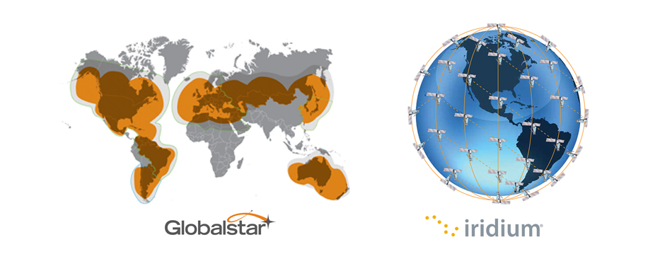
There are two main satellite networks: Globalstar and Iridium. If you have a SPOT tracker you are using the Globalstar network, everything else is on Iridium network (inReach, Somewear etc.)
Globalstar network
SPOT trackers all go through the Globalstar network (SPOT LLC is a wholly owned subsidiary of Globalstar). The Globalstar network of satellites orbit on an inclination of 52 degrees, so they do not cover polar areas.
Globalstar has a network of ground stations around the globe. For a location to transmit via Globalstar the tracker must be able to see a Globalstar satellite which can also see a ground station. You can get an idea of where these ground stations are by looking at the SPOT Coverage map.
In New Zealand our closest ground station is in Dubbo (Australia) so tracking typically works best in the west or on westerly facing slopes – they don’t work well if there’s a big hill close by on the west. SPOT trackers don’t work well under dense forest cover. SPOT trackers provide a good, reliable, cost effective solution to events – as long as the forest isn’t too thick. SPOT trackers are typically one-way, you can send out but you can’t receive messages.
Iridium network
The Iridium network has full global coverage due to the different inclination of 86.4° and the way they transmit. Unlike Globalstar satellites which “bounce” from a satellite straight down to the ground, the Iridium satellites communicate with one another. A message sent on the Iridium network sends from the device up to the satellite then via up to 4 other Iridium satellites before heading back down to earth at the ground station in Texas, USA. It means that any satellite visible can be used to send or receive messages (or calls via Iridium satellite phones).
The most well known devices on the Iridium network are the inReach messengers. In our testing, inReach messengers work better than any other device under forest canopy, as a device they are very well designed and work really well as a satellite messenger.
However, at MAProgress, we’ve found inReaches unreliable when used as a tracking device on an Unlimited plan. Garmin has what appears to be very attractive unlimited plan pricing, but note in the fine print “Top users may experience decreased message speeds”. Note that all other companies that provide unlimited plans for inReach devices will be subject to the same issue. In reality, what this means is that occasionally (and unpredictably) no tracking or messages will be transmitted for a number of hours – we’ve seen at least 12 hour gaps, and have heard of up to 24. Therefore, at MAProgress we don’t advise using inReach messengers for long distance events where you would use the tracker for 12 hours or more continuously. Tracking for less than 12 hours seems to be much more reliable. Note that SOS messages are unaffected, and the data will be available eventually, however, they are not reliable enough for real-time tracking.
In our next technology blog post we’ll be sharing an overview of current satellite communication devices – both for live tracking and two-way communication. If you have any other questions, please get in touch. We plan to release tech-focused blogs on a regular basis.